 |
Kotlas - Waterville Area Sister City Connection P.O. Box 1747 Waterville, ME 04903-1747 Write to Us |
 |
|
Home > About Kotlas > Northern Dvina About the Northern Dvina River
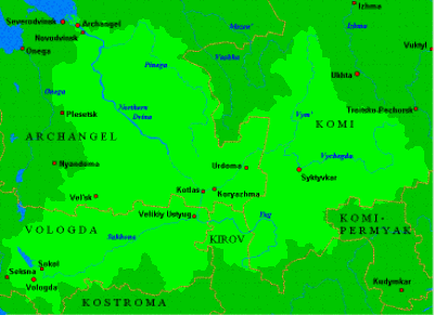
The expanses of the European North are unbounded. Thick pine forests lead right up to wide rivers filled with plentiful waters that slowly and majestically flow to the Arctic Ocean. One of the largest and most beautiful of these rivers is the Northern Dvina. It flows from the southeast to the northwest through the whole of the Archangel Region and empties into the Dvina Bay of the White Sea. The mighty Northern Dvina begins in the Vologda Region, near Velikiy Ustyug, with the confluence of the Sukhona and Yug Rivers. The current of the river is slow and peaceful. Its largest tributaries are:
Its length from its source to its mouth is 462 miles. It is navigable for its entire length. The total length of the navigable routes of the Northern Dvina basin exceeds 3,400 miles. (A basin, or watershed, is the total territory drained by a river and its tributaries.) The area of the basin is 138,000 square miles (larger than that of Finland.) The only sizeable towns along the rivers course are Velikiy Ustyug and Kotlas in the south and Archangel and Novodvinsk in the north. The seaport of Severodvinsk lies just west of the river's delta. Paired railroad and highway bridges cross the river at Velikiy Ustyug, Kotlas, and Archangel. Conventionally the Northern Dvina is divided into two sections. The first 46 miles, until the confluence of the Vychegda, is called the Little Northern Dvina, although in width and quantity of water it is not a small river. The total width of the river with its branches exceeds 650 yards, with the main channel being 200 yards wide. After the confluence of the Vychegda, the amount of water in the Northern Dvina doubles and it gets the name Great Northern Dvina. The river meanders through the valley, sometimes narrows to 260 yards, and then widens to 650-1300 yards, depending on the number of branches. Beyond the mouth of the Vaga (about 150 miles upriver from Archangel,) begins the most beautiful section of the Northern Dvina. The river flows here for a long way as a single channel. Its valley narrows, cutting deeply into gypsum of the Permian period (i.e., 220-270 million years ago.) In places the flood plains disappear completely. The white, forested cliffs are as beautiful as in a fairy tale. They reach heights of 160-190 feet. Having cut through the thickness of gypsum blocking its path to the sea, the Northern Dvina again spreads out into branches. Below Ust-Pinega (50 miles upriver from Archangel), begins the Northern Dvina estuary. There the river flows in several channels, and it is difficult to determine which is the main one. The width of the river in the estuary averages 650-900 yards, but near the village of Uyma it reaches 2200-2700 yards (i.e., 1¼ to 1½ miles.) The height of the banks gradually lessens. At Archangel the banks rise about 30 feet above sea leve. The delta of the Northern Dvina is 23 miles long and up to 28 miles wide. (The delta covers 425 square miles.) It is a labyrinth of more than 150 channels, the outlines of which change before ones eyes under the effect of the tides of the sea. Seventy-one per cent of the water that flows into the Northern Dvina and its tributaries is the runoff from rain and. The rest comes from ground water. In the winter the rivers are fed only by ground water. Only 7-8% of the water that flows through the Northern Dvina river system in the course of a year flows during the winter. The awakening of the northern rivers in the spring is a majestic and sometimes threatening, spectacle. Peaceful and unhurried in the summer, they become unrecognizable in the spring. Their waters surge headlong, submerging the flood plain. They carry away bridges and pull out trees by their roots. Even small, barely audibly, gurgling brooks turn into raging currents in the spring. In the spring, 50-65% of the yearly flow is carried by the rivers of the Northern area. The water sometimes rises by 22-38 feet. The height of the floodwaters is determined not only by the amount of snow, but also by the moistness of the soil the previous fall, the depth of the frost, and the speed at which spring arrives. Spring flooding on the Northern Dvina begins in the last half of April or the beginning of May. The river freezes in the latter half of November and is under ice for 5 to 6 months. During the spring ice flow there are jams, which cause the level of the water to rise very high. Navigation on the Northern Dvina is carried out for up to six months, on average for 175 days. From spring until late fall countless caravans of timber rafts (long logs laid side by side and tied together) used to move down the river. There are more than a dozen timber industry enterprises on the Northern Dvina, and one right after another along its banks are dams for timber, lumbering stations, and villages for their workers. More than half the lumber harvested in the Archangel Region went by float to Archangel. Loose log floats caused great damage to the river. The riverbanks caved in and didn't get restored. The river bottom was littered with sunken logs, causing the river to become shallower, fish to die, and sandbars to form. At present, log floats on the river are prohibited. The main wealth of Northern Russia is its forests. Commercial harvesting started in the 17th century. (80% to 95% of the Northern Dvina basin is forested. Much of the rest is swampland.) Does the cutting of timber have an influence on the flow of the river? The river and its basin are inseparable. Forests slow the spring snow melt and slow the runoff of melt water and rain, not only stretching out the period of high water, but also increasing the absorption of water into the ground. But the main regulatory role of the forest is to smooth out the seasonal and multi-year variations in the runoff. In dry years, less water evaporates from the forest than the fields, and in wet ones, more. The forests not only influence the water balance, but also protect the soil from erosion, the banks of the rivers and lakes from cave-ins, and the riverbeds from siltation. The main source of pollution of the Northern Dvina is the pulp and paper industry. Due to its wastewater, very high concentrations of lignosulfurous and various organic substances can be found. The amount of suspended and organic substances in the mouth of the Northern Dvina exceeds the norm by 2-4 times. Each year the waters of the Northern Dvina dump about 23 billion cubic feet of polluted industrial wastewater into the Dvina Bay of the White Sea. All this mass builds up in the same places and thus devastates all organisms inhabiting or using this water. The water contains a series of ingredients harmful to man: petrochemical products, copper, iron, mercury, sulfates, nitrates of various acids, and others. Boat traffic is also a serious problem. Speeding boats suck up water, forcing it back from the shores and often exposing parts of the river bottom. Then all this mass of water surges back with force, splashing onto dry land to a distance of several meters if the shores are low. Of course it is difficult for water plants and fish eggs to remain intact in this "surf zone." Acknowledgements: Most of this article was taken from a report by Aleksandr Sinitsyn, one of our Rivers Project students. The paragraph about the timber rafts and the subsequent paragraphs came from a report by Yevgeny Semenov. Pat Hanson translated both reports. Gregor Smith edited the excerpts for publication and added the paragraph about the cities along the Northern Dvina and the italicized remarks that appear elsewhere in the article. He also converted the metric measurements in the original reports to English units and prepared the map of the watershed. |
